Home] -
Live Cams] -
Current WX] -
Forecasts] -
Radar] -
Satellite] -
WX Maps] -
Long-Range] -
Precip] -
Climate] -
Links] -
Weather Links

Radar Images 
KPRC Doppler 2000 . 
Intellicast . 
More... . 

Satellite Images 
Infra-Red . 
Water Vapor . 
More... . 

Local Forecasts 
WeatherPages.com . 
USA Today . 
More... . 

WeatherPages 
Live Cams . 
Fcst. Models . 
Browse . 
Visible

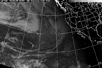
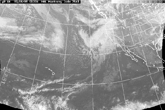
The visible satellite image is the same as seeing the earth from the window of a spaceship (although it is usually black & white). Clouds appear very detailed. The bright white areas represent the highest cloud-tops where the heaviest precipitation is located. One drawback is that visible satellite pictures are only useful during the daytime, because clouds are not visible without the sun, and the picture is black at night.

Infra-Red

The infra-red satellite image uses infra-red light to detect clouds. Although it does not provide as much detail as the visible picture, it is very useful because clouds can be seen at any time of the day or night. Again, the brighter white areas represent higher cloud-tops and heavier precipitation.

Water Vapor

Instead of using light to take a picture of the cloud-tops, the water vapor satellite is capable of detecting how much moisture is in the clouds. Sometimes it is a little misleading because it shows proportionally too much water vapor closer to the poles. Water vapor satellite images can be color coded, but are usually black and white. In the black & white version, the brighter colors indicate more water vapor in the clouds, and consequently more potential for precipitation.

  <<
back to main satellite page
WeatherPages for:


Weather
Home| Features| News| Search| Chat| Links| History| Feedback

Copyright © 1998 Matt Haugland. All rights reserved.
Satellite Information - Texas

Houston Weather

Houston Weather

 
Search